|
KURE
ISLAND
Kure,
more familiarly known as
Ocean Island, is the northwesternmost
island of the Hawaiian Archipelago.
It is 1,200 miles northwestward
of Honolulu and 56 miles
west of Midway Islands.
It is
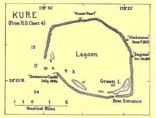
an atoll, circular in outline,
the reef being about 15
miles in circumference or
6 miles in greatest diameter.
There is an opening through
the reef on the southwest
side, but only small craft
can enter. Along the south
side of the lagoon are one
small island and two sand
banks.

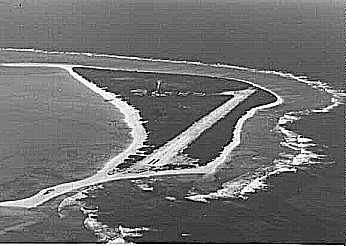
Green
Island is about a mile long
by less than half a mile
wide. It occupies the southeast
corner of the lagoon. It
is somewhat crescent-shaped,
and is bordered all around
by a nearly continuous line
of sand dunes, which rise
steeply from the waters
edge to a height of up to
twenty feet above the sea.
The dunes are highest on
the northeast end, those
on the south and east reaching
an elevation of only about
ten feet. Within there is
a trough depression, the
floor of which is about
eight feet above sea level.
The western point terminates
in a long sand-spit.
The dunes
and most of the interior
of Green Island are covered
with a dense, almost impenetrable
stand of beach Scaevola,
a much branching, coarse
shrub, with large, glossy
green leathery leaves, small
white "half flowers",
and pithy white fruits the
size of small marbles. On
Green Island

this
shrub reaches a height of
five to six feet. The shrub
is called "naupaka
kai" by the Hawaiians,
and is a familiar low beach
plant on the main islands.
It has been nicknamed "beach
magnolia" by persons
on Midway. It is an abundant,
widespread littoral plant
throughout the Pacific.
Toward the eastern end there
is an open grassy area of
about twenty acres, surrounded
by the barrier of Scaevola.
Here are found most of the
other species which make
up Kure's flora of thirteen
kinds of vascular plants.
Between
Green Island and the lagoon
entrance there are generally
two other islets, lying
close to the southern reef.
They are low mounds of sand
and broken coral, usually
devoid of vegetation. In
1923, when the atoll was
visited and explored by
the Tanager Expedition,
the more western was about
a mile long by a quarter
of a mile wide, and ten
feet high. The shape of
all three islets differ
on maps made at different
periods, such as that made
by the U.S.S. Lackawanna
in August 1867, and that
by Captain Brown, of the
ship Gledstanes, published
in the Hawaiian Spectator
for July, 1838. This would
suggest that much shifting
of sand has been done by
storms.
The southern
portion of the reef is scarcely
awash at low tide. But most
of the rest of its circumference
is covered with a line of
coral boulders which protrude
above the water. The waves
break heavily on the northern
and eastern curve of the
reef during normal trade
wind weather. At such times
vessels may anchor off the
west side in eight to twelve
fathoms of water. At times
of storms the reef must
present an awesome sight.
Captain
Kure, a Russian navigator,
is said to have discovered
the atoll, but no authentic
account of this is available.
The British ship Gledstanes,
Captain Brown, was wrecked
on the weather side of the
reef, July 9, 1837. The
whole ship's company lived
on Green Island until December
15. Then Captain Brown and
eight seamen sailed east-southeast
in a schooner which they
built with great toil from
fragments of the wreck.
After many hardships they
reached Honolulu and, through
the help of the British
Consul, a vessel was sent
to Kure which brought off
the rest of the officers
and crew. On September 24,
1842, the American whale
ship Parker also was wrecked
on Kure, the crew being
rescued in a similar manner
in May, 1843.
In the
history of Kure the most
remarkable shipwreck was
that of the U.S.S. Saginaw.
This vessel had been sent
to Midway in March 1870,
with a party of divers and
engineers who were to dredge
a passage through the reef
into the lagoon. After the
$50,000 appropriated by
the United States Congress
for the job had been spent,
with the work only part
done, the plan was abandoned.
Before returning to San
Francisco Captain Sicard
decided to visit Kure to
see if there had been any
more shipwrecks on the island.
The night of October 28-29
was clear and the wind fair,
as the Saginaw steamed slowly
across the intervening fifty
miles, planning to arrive
at daybreak. At 2.30 a.m.
the engine was stopped.
A short time later the lookout
sighted breakers ahead,
and the engine was started
in reverse. But within a
few minutes the steam connection
burst, and in a very short
time the helpless vessel
had drifted onto the east
reef. The waves pounded
so hard that soon the hold
was full of water, and at
5.00 a.m. word was passed
to abandon ship. All of
the 93 members of the crew
and dredging party were
gotten safely ashore, but
comparatively little was
salvaged from the ship before
she broke up, except some
water-soaked food and a
small boiler, which later
was very useful in distilling
water. Lieutenant Talbot
and a volunteer crew of
four, two of whom were divers,
set off in the specially
decked and fitted Captain's
gig. They made the voyage
to Kauai in thirty days,
after incredible suffering,
having encountered three
severe gales in which they
lost their oars and provisions
overboard. They were so
weak that, in trying to
get ashore near Hanalei
the boat capsized and all
but William Halford, the
coxswain, were drowned.
He succeeded in getting
word to Honolulu, so that,
through the kindness of
the Hawaiian Government,
the steamer Kilauea was
dispatched on December 26,
reached Kure on January
3, 1871, and brought the
remainder of the party safely
to Honolulu on the 14th.
The Dunnottar
Castle, a British ship,
was wrecked on Kure July
15, 1886. The crew managed
to reach Kauai by boat,
but several lives were lost
in making a landing. As
a result of this, King Kalakaua
sent Colonel J. H. Boyd
as his Special Commissioner
to Kure. On September 20,
1886 he took possession
of the island, then called
Moku Papapa, for the Hawaiian
government. The King caused
a rude house to be built
on the island, with tanks
for holding water and provisions
for any other unfortunates
who might be cast away there.
But the provisions were
stolen within a year, and
the house soon fell into
ruins.
The provisional
Government of Hawaii leased
the island to the North
Pacific Phosphate and Fertiliser
Company for 25 years from
February 15, 1894; but no
extensive guano digging
was done.
Kure was
one of the islands acquired
by the United States on
July 7, 1898, when Hawaii
became a Territory. In April
1909 it was made part of
the Hawaiian Islands Bird
Reservation.
Bird life
is less abundant on Kure
than on other islands of
the chain. The island is
overrun with rats, but they
could hardly account for
the scarcity of sea birds,
as a peaceful balance generally
is established between this
kind of "Polynesian
rat" and sea birds.
The Hawaiian or hair seal,
Monachus schauinslandi,
was frequently found on
Kure, and turtles are said
to be common. Thirty-five
species of insects were
identified from specimens
collected by the Tanager
Expedition, which visited
the atoll in April, 1923,
and made a careful biological
survey.
|